
How GNSS Positioning Systems Support Disaster Response and Recovery
Global Navigation Satellite Systems (GNSS) have become crucial tools in modern disaster response and recovery efforts. These satellite-based systems provide accurate location data, which can significantly enhance the effectiveness of emergency operations during natural disasters. In this article, we will explore how gnss positioning system support disaster response and recovery, focusing on their role in search and rescue operations, damage assessment, and coordination of relief efforts.
Understanding GNSS Technology
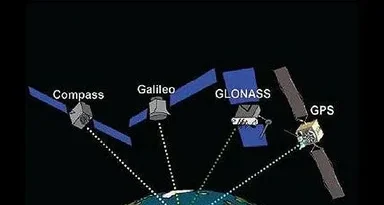
Before delving into how GNSS systems support disaster response, it’s essential to understand the technology behind it. GNSS refers to a collection of satellite systems that provide geolocation services. The most widely used GNSS systems include:
- GPS (Global Positioning System) – Operated by the United States.
- GLONASS – Operated by Russia.
- Galileo – Operated by the European Union.
- BeiDou – Operated by China.
These systems work by providing real-time location data to GNSS receivers, which are then used to determine the exact position of objects or people. This capability is vital during a disaster, where rapid, accurate location information can save lives and improve recovery efforts.
GNSS in Search and Rescue Operations
In the aftermath of natural disasters like earthquakes, floods, or hurricanes, search and rescue (SAR) teams face immense challenges in locating survivors and delivering aid. GNSS positioning systems play a key role in these efforts.
1. Locating Survivors
One of the primary ways GNSS supports disaster response is by helping rescuers pinpoint the exact location of survivors. GPS-enabled devices, including mobile phones and emergency beacons, allow rescuers to track the position of people in need of assistance, even in remote or hard-to-reach areas. In some cases, search teams use drones equipped with GNSS technology to fly over disaster zones, mapping areas and identifying locations where survivors might be trapped.
2. Efficient Route Planning
During rescue missions, it’s not just about knowing where people are, but also finding the quickest and safest route to reach them. GNSS allows rescuers to navigate complex, debris-filled environments or unfamiliar terrain. By using GPS devices, SAR teams can chart the fastest, most efficient paths, reducing response times and ensuring aid reaches victims faster.
GNSS for Damage Assessment and Mapping
After an immediate disaster response, assessing the extent of the damage is crucial for effective recovery planning. GNSS systems are invaluable in mapping and surveying disaster zones, offering high accuracy in collecting geospatial data.
1. Mapping Destruction
GNSS-enabled surveying equipment allows authorities and relief organizations to generate detailed maps of disaster areas. These maps provide a clear picture of the severity of the damage and help in decision-making about resource allocation. For example, if entire neighborhoods are destroyed by an earthquake or flooding, maps generated through GNSS data can help identify where recovery efforts should be focused first.
2. Tracking Infrastructure Damage
Critical infrastructure, such as bridges, roads, and power lines, is often damaged during disasters. GNSS positioning systems allow for precise assessments of infrastructure damage, helping engineers and planners decide what needs immediate repair or replacement. This geospatial data also aids in preventing unnecessary repair work in areas that are not as severely affected.
Coordination of Relief Efforts
Efficient coordination of resources, volunteers, and aid supplies is another area where GNSS systems excel. Relief efforts often involve multiple agencies, organizations, and teams, all working in different parts of a disaster zone. GNSS technology enables smooth coordination and communication between these various groups.
1. Real-time Monitoring of Resources
GNSS-based tracking systems can be used to monitor the movement and deployment of emergency resources such as food, water, medical supplies, and personnel. By having access to real-time location data, disaster management teams can ensure that supplies reach the areas where they are most needed, preventing bottlenecks or delays.
2. Collaborative Platforms
With GNSS, various relief organizations can share their location data through collaborative platforms, improving overall coordination. Teams can track the position of both relief convoys and emergency teams, ensuring they are not duplicating efforts or working in areas that are already well-covered.
GNSS in Long-Term Recovery
While GNSS positioning systems are vital in the immediate aftermath of a disaster, they also play an important role in long-term recovery. As the rebuilding process begins, geospatial data from GNSS systems helps to plan the reconstruction of homes, infrastructure, and public services.
1. Urban Planning and Reconstruction
After the destruction caused by natural disasters, urban planners use GNSS data to redesign cities or towns more resiliently. By analyzing the geospatial data collected during damage assessments, planners can decide on safer locations for new infrastructure, taking into account flood zones, fault lines, or other natural hazards.
2. Monitoring Recovery Progress
Throughout the recovery phase, GNSS can be used to monitor and assess progress. By tracking the movement of resources, buildings, and people, authorities can determine if recovery efforts are proceeding as planned or if adjustments are necessary.
Conclusion
In conclusion, GNSS positioning systems are indispensable tools in disaster response and recovery. From aiding in search and rescue missions to supporting damage assessment and ensuring the efficient coordination of relief efforts, GNSS technology contributes significantly to saving lives and rebuilding communities. As natural disasters continue to pose serious challenges worldwide, the role of GNSS will undoubtedly remain critical in improving the speed, effectiveness, and efficiency of disaster management strategies.